Light snow ends Tuesday evening, icy roads possible overnight
Even though the big snowfall is coming to an end, roads could still be icy Wednesday morning with wind chills near and below zero across the whole state Wednesday and Thursday morning.
Light snow continues around the Twin Cities early this evening, then comes to an end after sunset. Metro totals for today should range from about 3 to 4 inches in most locations.
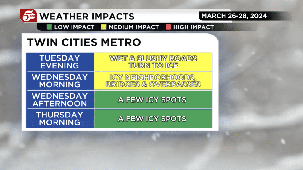
Roads are still rather slushy right now, but once there are fewer cars overnight, those slushy spots are going to freeze. Icy conditions are possible during the Wednesday morning commute, especially in neighborhoods and along bridges and overpasses. Expect to take a little more time getting to work and school tomorrow.
A Winter Weather Advisory is in place for multiple counties in the state, with Winter Storm Warnings in place for northern Minnesota. CLICK HERE for a complete list of current weather alerts.
The conditions have led some districts to cancel after-school activities.
It is going to be cold Wednesday morning! Temperatures fall into the teens and wind chills will range from -5° to -5° over all of Minnesota and northwest Wisconsin. Clouds likely hold north of I-94 Wednesday, and scattered snow showers are possible in northeast Minnesota and northwest Wisconsin. Up to an inch of additional accumulation is possible. There is one more cold morning on Thursday before temperatures start to warm up for Easter weekend. Highs in the low to mid 40s are likely from Friday into next week.
There are some rain chances over the weekend, but most of it should be overnight. The first round comes Friday evening into the night. There might be a couple lingering showers on Saturday. More widespread rain is likely Sunday night through Monday. As cooler air moves in Monday night, some snow is possible by Tuesday morning. At this point, it is something we are watching and nothing to get excited about.
The Minnesota State Patrol said that from 4:30 p.m. on Monday to 4:30 p.m. on Tuesday, there were 288 crashes (19 of which involved injuries and 0 were serious/fatal), 257 vehicle spin-outs and 31 jackknifed semis.
An interactive traffic map can be found below. Traffic reporter Hanna Conway will post updates on social media HERE.
Late Tuesday morning, the Minnesota Department of Transportation issued a no travel advisory for a section of I-90, running from Worthington to Jackson, due to strong winds causing snow to blow across the highway, causing limited to zero visibility. However, that has since been lifted.
Dozens of school districts have decided to delay start times or cancel classes for the day. A full list of school cancellations can be found by CLICKING HERE. Additionally, both Minneapolis and St. Paul schools have canceled after-school activities.
As previously reported, the region is receiving about a month’s worth of precipitation in a matter of days, and while it isn’t solving Minnesota’s drought problems, it is helping. The latest DNR drought map released last Thursday shows at least 74% of Minnesota is in a moderate drought.
Parts of north-central Minnesota and western Wisconsin have received about a foot of snow from this system, which began moving through the region Sunday morning.
RELATED: Snowfall totals from spring snowstorm
Any precipitation that has fallen before 7 a.m. Tuesday will be included the National Drought Monitor’s report that is released every Thursday at 7:30 a.m.
If you’d like to share snow photos with KSTP-TV, CLICK HERE to do so.
Sunshine and cold weather will be back on Wednesday. The latest forecast can be found by CLICKING HERE.