Forecast First Alert: Strong storms possible the afternoon, evening hours on Thursday
A Forecast First Alert has been issued by Minnesota’s Weather Authority due to a slight risk of severe weather on Thursday.
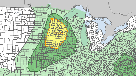
According to 5 EYEWITNESS NEWS Chief Meteorologist Ken Barlow, storms will be possible across the state, with the slight risk area including the Twin Cities metro area and stretching from north-central Minnesota and south into central Iowa and parts of western Wisconsin.
A marginal risk area stretches even further north to parts of northern Minnesota, west to include areas near Bemidji and southwest to include parts of South Dakota.
This latest alert comes a few days after severe storms caused thousands of power outages across Minnesota and Wisconsin and trees to be uprooted.
RELATED: Power restoration, cleanup efforts continue Wednesday
Thursday is expected to be warm and humid ahead of the storms, with highs reaching the lower to mid-80s. CLICK HERE to find the current dew points.
You can share photos and videos of severe weather by CLICKING HERE. You can find an interactive radar by CLICKING HERE.
To get the latest alerts for severe weather headed in your direction, make sure to download the KSTP news app, where you can get alerts on the approaching storm system and watch our live broadcast. You can do so for your device by CLICKING HERE.
RELATED: Forecast First Alert Explained