Forecast First ALERT: Winter Storm Moving into Minnesota
A Forecast First Alert is in place today and Monday for the entire KSTP viewing area. Winter Storm Warnings are in effect for most of Minnesota with Blizzard Warnings along the north shore. Winter Weather Advisories are in effect across parts of southern Minnesota from Sunday through Monday.
We’ve seen a few light snow showers already this morning, with an inch or two south of the Minnesota River to a dusting in the south metro. After the noon hour today, steady to heavy snow will move across the southern half of Minnesota and northwest Wisconsin. This is when roads will start to get snow covered and slippery, and travel will become much more difficult.
Heavy snow continues this evening through the beginning of the overnight hours into Monday. The most difficult part of this forecast has always been when and where the rain will start to move in Sunday night into Monday morning. Recent trends have been a little slower with that changeover. At this point—in the Twin Cities—the snow should start to change to rain after about 3:00 – 5:00 AM. Farther to the northwest, especially north or west of St. Cloud, it will continue as steady to heavy snow through Monday morning. This is where some of the highest snow totals will be for this entire storm.
In the Twin Cities on Monday, rounds of rain are likely, and perhaps even a rumble of thunder. Dryer air will start to move in Monday afternoon, so there will be a time where rain will become light, or we could even get a couple of dry hours. As this entire system pulls away to the east Monday night, and into Tuesday, colder air will return, and we will end with more snow.
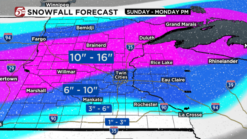
Snow totals in the Twin Cities will range from 6 to 10 inches, if this forecast holds with the timing of the rain. If we need to change the timing of the rain, snow totals will change as well, so make sure you are staying up-to-date with the latest forecast from Minnesota’s Weather Authority as we go through Sunday. In parts of western and northern Minnesota, this will all be wet snow. Totals will range from 10 to 16 inches anywhere from Marshall to Alexandria to Brainerd to Duluth.
Overall, if you do not need to drive outside of your neighborhood Sunday afternoon through Monday morning, it is not recommended. Road conditions will improve quickly Monday afternoon with the rain. Another inch or two of snow is possible as cold air wraps in Monday night into Tuesday. Once the snow ends on Tuesday, we get a dry stretch of weather for a few days with seasonably cool temperatures in the 30s
– Meteorologist Chris Reece