‘Unprecedented’ December weather expected Wednesday, Tornado Watch issued
[anvplayer video=”5078052″ station=”998122″]
Meteorologists are monitoring as a system with the potential for damaging winds and severe thunderstorms is moving into the region Wednesday.
The National Weather Service (NWS) has issued multiple advisories for the region, adding Wednesday’s forecast hasn’t been seen before in mid-December and is unprecedented.
A Tornado Watch was issued for much of southern Minnesota, parts of central Minnesota and west-central Wisconsin at 5:30 p.m. and is set to expire at 11 p.m.
Photos from viewer Hailey Johnson in Hartland, Freeborn County. #mnwx
— KSTP (@KSTP) December 16, 2021
1. Hartland Bank with windows blown out.
2. Damage to Olson Excavating building across the street to the south of the bank.
We’ve got the latest on this "unprecedented" storm system at https://t.co/mB0vvJ4kyL pic.twitter.com/M4sK7j4MmV
At 8:18 p.m., the NWS said there was a reported tornado in Plainview, in Wabasha County, and the storm is expected to continue northeast in parts of Pepin County and southern Dunn County.
A high wind warning is also in effect overnight for much of the area overnight and the NWS warns of freezing fog and heavy snow rolling in.
These conditions will develop in western Minnesota, so please don’t travel if you don’t have too. A Winter Storm Warning is in effect #mnwx pic.twitter.com/0PzGanWcTX
— NWS Twin Cities (@NWSTwinCities) December 16, 2021
KSTP Meteorologist Wren Clair reports widespread severe weather is expected to enter southern Minnesota Wednesday evening, with fast-moving thunderstorms as part of the mix.
KSTP Meteorologist Wren Clair reports widespread severe weather is expected to enter southern Minnesota Wednesday evening, with fast-moving thunderstorms as part of the mix. [KSTP-TV]
Clair advises having a severe weather plan in place.
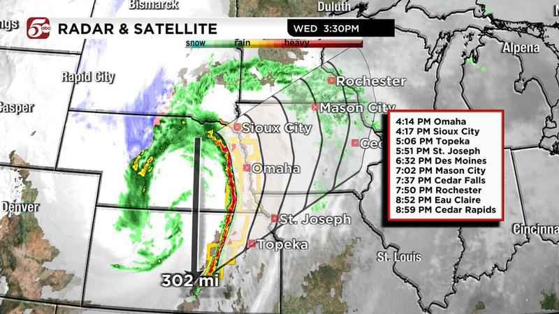
Line of storms extending approx. 300 miles long producing widespread severe t’storm warnings and tornado warnings. Severe weather enters southern MN this evening, with fast moving t’storms. Have a severe weather plan in place now. @kstp pic.twitter.com/0brq2q19z8
— Wren Clair (@WrenClair5) December 15, 2021
According to the NWS, wind gusts of more than 80 mph are possible, and storms will be moving between 60-70 mph. KSTP Meteorologist Matt Serwe says severe storms in the summer typically move around 30-50 mph.
KSTP Meteorologist Jonathan Yuhas said evening storms are expected to last until around 9 p.m.
Calm conditions are expected to briefly return until more high winds will cause temperatures to drop and roads to freeze over during the overnight hours and through Thursday morning.
Wind gusts of more than 60 mph are expected with the overnight front.
Severe T’storm Warning for Blue Earth, Le Sueur, Waseca Co. through 7:45 PM. 60 mph wind gust, tornado possible, cell tracking northward at 60 mph. Seek shelter within warning area. @kstp pic.twitter.com/ftoKCQPaaM
— Wren Clair (@WrenClair5) December 16, 2021
Wednesday afternoon, the Metropolitan Airports Commission said due to the strong winds, air traffic controllers may direct aircraft to use the crosswind runway instead of the parallel runways. If that happens, residents near the airport may notice unusual flight patterns when the parallel runways aren’t being used.
In addition, those traveling by air out of MSP should check their schedule for disruptions, with officials saying regularly scheduled arrivals and departures may be delayed into the overnight hours, or canceled.
Chief Meteorologist Ken Barlow reported a record high temperature was reported at Minneapolis-St. Paul International Airport, at 52 degrees. The record was previously set at 51 degrees in 2014. Barlow reported temperatures are expected to continue rising Wednesday.
These are the warmest December temperatures on record in the Twin Cities. We could end up on this list today (though the top spot should be safe).
— Matt Serwe (@SerweWX) December 15, 2021
Right now it’s 48° at MSP, but there are 60s just over the Iowa border. It’s possible our high temp comes after sunset too! pic.twitter.com/c1dEDKZifp
Tips to prepare during severe weather
Wondering what to do to keep you and your family safe? Here are a few tips offered by Serwe:
- Pay attention to trusted weather sources.
- Plug in and turn on weather radios, and also put fresh batteries in your radio. Due to the potential of strong winds, the chances for power outages are also higher.
- Check that Wireless Emergency Alerts (WEA) are turned on in your phone.
- Think about your severe weather plans, and if your family may be going out, find out where your shelter will be if a severe storm approaches.
- Bring items inside which could blow around, such as garbage cans and large holiday decorations in your yard. Additionally, stay away from any damage from strong winds, as broken glass or other sharp objects, along with building materials and trees, could cause serious injury.
- Clear snow away from downspouts so water can get away from your home, as well as storm drains found near your property. Clearing the snow will limit how much ice can form when temperatures drop overnight.
- Make sure friends and family members who live in areas listed in NWS advisories and warnings are aware of the potential for severe weather.
- Those who must drive are advised to use caution, slow down, use headlights, and leave plenty of distance between vehicles.
Earlier, foggy and drizzly conditions lasted through the lunch hour.
Members of the Minnesota State Patrol reminded drivers to turn on their headlights due to the fog, adding automatic lights may not come on during daytime hours.
Headlights on! We all know the fog is causing visibility issues. For your safety and the safety of others, please turn your headlights on while traveling. Your automatic lights might not always activate during the daylight hours, so make sure you are turning them on manually. pic.twitter.com/V1bgBeuI84
— MN State Patrol (@MnDPS_MSP) December 15, 2021
Storms are expected across the state today and that could include heavy rains.
— MN State Patrol (@MnDPS_MSP) December 15, 2021
Motorists:
o Turn on your lights, it’s the law during any precipitation.
o If rain becomes too heavy to see, find an exit and drive to the nearest parking lot to ride out the storm.
Meanwhile, earlier Wednesday traffic cameras showed multiple crashes between 490th Street near Pine Island and 480th Street near Zumbrota caused a closure of northbound US 52, and a detour was in place until about 11:30 a.m.
TRAFFIC ALERT:
— ABC 6 News – KAAL TV (@ABC6NEWS) December 15, 2021
The Minnesota 511 website reports the crash as being between 480th St and MN 60.https://t.co/QDislPGYg3
State Patrol is investigating a fatal crash on USTH 52 & MP 69, near Pine Island. Crash involves 3 commercial vehicles and 3 passenger cars. USTH 52 N/B will be closed for several hours. When information is available it will be on the media page.
— Sgt. T. Christianson (@MSPPIO_SOUTH) December 15, 2021