The latest on snow across Minnesota, Wisconsin Sunday night into Monday

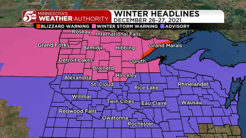
Winter weather headlines December 26-27, 2021[KSTP]
Snow is already falling across southwest and western Minnesota Sunday afternoon. It spreads across the remainder of the state tonight, becoming steady to heavy at times. Widespread travel impacts are likely after sunset Sunday.
A Winter Storm Warning is in effect for northern Minnesota through most of Monday. A Winter Weather Advisory is in effect for the southern half of Minnesota and northwest Wisconsin through early Monday morning.
Snow starts in the Twin Cities metro around 6:00 p.m. Sunday evening. Bands of steadier snow are likely through midnight. As warmer and drier air pushes in overnight, it’s possible that some freezing drizzle mixes in with some snow showers after midnight. Any ice accumulations should remain light and isolated in the Twin Cities, but a few hundredths of an inch of ice are possible in southern Minnesota.
Accumulations will be the lowest in southern Minnesota and go up heading north. South of the Twin Cities, only an inch or two is expected. In the metro, most totals should range from 2-4 inches. An isolated 5-inch total is possible in the north metro. Central Minnesota totals should range from 4-inches around St. Cloud and Alexandria. Northern Minnesota should get 6-10 inches of snow, with more than a foot in the lake effect snow belts between Duluth and Grand Marais.
Winds pick up overnight, and continue to gust around 40 mph through Monday. This could cause blowing and drifting of snow through the morning commute on Monday, keeping roads snow-covered and slippery. These winds will also drive temperatures into the low 20s Monday afternoon, with wind chills in the single digits.
There is more accumulating snow in the forecast on Tuesday! Expect another round of 2-4 inches across most of Minnesota Tuesday afternoon through the evening.