Forecast First Alert continues Monday for messy roads after heavy snow, rain
Here’s your Sunday night forecast for March 25, 2024 from Minnesota’s Weather Authority and Meteorologist Matt Serwe.
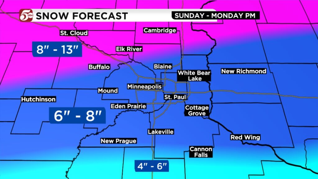
The Forecast First Alert continues Sunday into Monday. Heavy snow is likely in the Twin Cities Sunday evening and overnight, then changing to rain Monday. Central, western, and northern Minnesota should see almost all snow.
As of 10:00 PM, snow totals are generally in the 4 to 6 inch range in the Twin Cities metro. Snow is starting to change to rain around Mankato and Owatonna, and that will move into the metro after midnight. Before we change to rain, there should be about 6 to 8 inches of snow in the Twin Cities from this storm. If you are measuring this snow Monday morning, it could have already melted down much lower.
Farther northwest, the steady to heavy snow continues overnight into Monday. From Alexandria to St. Cloud to Brainerd and Duluth, 8 to 13 inches of snow is likely through Monday afternoon. In addition, wind gusts of 25 to 35 mph are possible, causing blowing and drifting in more rural areas.
From the metro to the south and east Monday, expect to wake up to cold, steady rain. Widespread rain is likely in the morning, then we should get more gaps between the rain in the afternoon. A few rumbles of thunder are possible too. A half inch to an inch of rain is possible in the Twin Cities on Monday. As a reminder, when you are clearing snow, make sure to clear it from storm drains so the rain has somewhere to go. Covered drains could lead to ponding and minor street flooding.
Temperatures fall Monday night into Tuesday, and more light snow is likely. 1 to 3 inches of additional snow is possible in the Twin Cities through Tuesday afternoon. 3 to 6 inches of additional snow is possible in parts of northwest Wisconsin. Temperatures stay in the 20s on Wednesday before we warm up by the end of the week. Looking ahead to Easter weekend, there is a small chance for rain or snow showers on Saturday. Temperatures should be in the mid 40s through the second half of the week.
An interactive map showing current traffic conditions can be found below.