Why does Vermont keep flooding? It’s complicated, but experts warn it could become the norm
")
Zac Drown, of Lyndon Electric Company, clears debris amid flood damage in Lyndon, Vt., Tuesday, July 30, 2024. (AP Photo/Dmitry Belyakov)[ASSOCIATED PRESS/Dmitry Belyakov]
Vermont is flooding. Not just yesterday, two weeks ago and a year before that, but experts say the state could see catastrophic events like these for the foreseeable future.
Climate change is fueling stronger, more persistent storms and the state’s infrastructure is feeling the effects in villages along the Green Mountains’ rivers and streams, which carry a huge amount of water.
Now, these towns are the epicenter of a flooding conundrum that state and federal officials are scrambling to resolve.
In the meantime, many homeowners are still trying to rebuild from floods just over a year ago — considered historic at the time, now becoming the norm.
A combination of factors leaves Vermont susceptible to these kinds of devastating floods. Here’s a look at a few, along with photos and video from the latest storms.
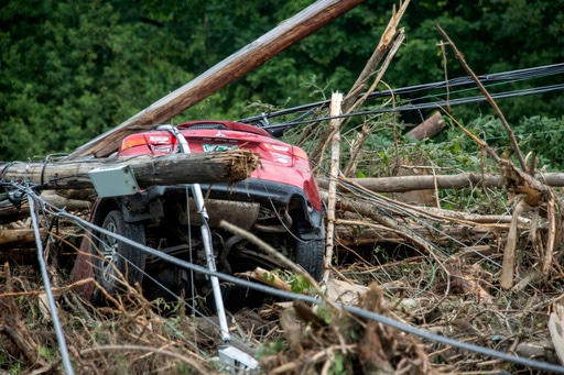
A damaged car sits amid flood debris in Lyndon, Vt., Tuesday, July 30, 2024. (AP Photo/Dmitry Belyakov)
Photo: ASSOCIATED PRESS/Dmitry Belyakov
Climate change warming the atmosphere
Extreme flooding conditions like these are often the result of random, short-term natural weather patterns heightened by long-term, human-caused climate change.
With climate change, storms are forming in a warmer atmosphere, making extreme rainfall a more frequent reality. The additional warming that scientists predict is coming will only make it worse, with the Northeast U.S. among the regions vulnerable to heavier rains in the future.
A warmer atmosphere holds more moisture, which results in storms dumping more precipitation that can have deadly or destructive results. For every 1 degree Celsius (1.8 degrees Fahrenheit) that the atmosphere warms, it holds approximately 7% more moisture.
A study last year in the journal Climate Change found that extreme precipitation in the Northeast will increase 52% by the end of the century. One of the study’s authors, Jonathan Winter, an associate professor of geography at Dartmouth College, also took part in research that found there had been a 50% increase in extreme precipitation events from 1996 to 2014.
Winter said the research found that the air’s ability to hold more water in a warmer climate is the primary force behind increases in extreme precipitation.
“This essentially gives storms more fuel, so that when you have the right conditions for an extreme precipitation event like the remnants of Hurricane Beryl, it creates a larger storm relative to what we would have experienced without climate change,” he said.
Mountainous terrain and saturated soil
Vermont has more than 7,000 miles (11,300 kilometers) of rivers amid rural roads that wind past sweeping vistas and treasured ski resorts. Its residents are scattered down dirt roads that run miles into the wilderness, many with streams flowing through their property to bigger rivers. Big mountains give way to deep valleys with rivers and streams throughout.
Many rural communities can quickly become cut off when roads wash away, and those living near waterways where people settled in the mill era are in danger of flash floods that move boulders, trees and cars past their homes.
Vermont has experienced four floods in the past year, and the combination of climate change and the state’s mountainous geography are big pieces of why, said Peter Banacos, science and operations officer with the National Weather Service in Burlington. Greater rainfall and increased moisture availability have made the state’s steep terrain more susceptible to flooding, he said.
The state’s soil also has been more frequently saturated, which creates more possibility of flooding, Banacos said.
“As we see more frequent rainfall events, oftentimes when they come in rapid succession, we have soil conditions that are more moist or saturated as the next rainstorm comes along,” Banacos said.
Heavily manipulated rivers
Vermont’s history of heavily manipulating its rivers and streams also plays a role in increased flooding, Vermont Agency of Natural Resources secretary Julie Moore said.
The flooding is “a reflection of having reached our limits of being able to truly manage rivers and hold them in place,” Moore said.
Infrastructure such as roads, bridges, culverts and wastewater facilities are especially vulnerable, Moore said.
The state is in the midst of a multidecade effort to harden infrastructure, with the goal to replace or repair structures “with our current and future climate in mind,” Moore said.
Vermont is also working to establish statewide floodplain standards.
A crumbling dam system
Dams in Vermont are increasingly at risk as climate change brings heavier rains and more powerful storms. Extensive flooding in the state last year led to five dams failing and nearly 60 overtopping. Even though the deluge from the remnants of Hurricane Beryl wasn’t so bad, dam officials were on high alert.
The challenge facing dams in Vermont is playing out across the country as more dams overtop or fail during heavy rains. The Rapidan Dam, a 1910 hydroelectric dam in Minnesota, was badly damaged last month by the second-worst flood in its history. And in Texas, flooding damaged the Lake Livingston Dam’s spillway about 65 miles (105 kilometers) northeast of Houston.
There are roughly 90,000 significant dams in the U.S. At least 4,000 are in poor or unsatisfactory condition and could kill people or harm the environment if they failed, according to data from the U.S. Army Corps of Engineers. They need inspections, upgrades and even emergency repairs.
Like the rest of New England, Vermont has mostly older, small dams built to power textile mills, store water or supply irrigation to farms. The concern is that these dams built decades ago — when climate-driven storms dumping huge amounts of rain were not a threat — have outlived their usefulness.
Copyright 2024 The Associated Press. All rights reserved. This material may not be published, broadcast, rewritten or redistributed without permission.