Just a Category 1 hurricane? Don’t be fooled by a number — it could be more devastating than a Cat 5
")
An upended tree lays on the rooftop of the Bethel Church in the aftermath of Hurricane Beryl, in Van Vleck, Texas, July 8, 2024. (AP Photo/Eric Gay)[ASSOCIATED PRESS/Eric Gay]
Here’s a troubling phrase hurricane forecasters hate but often hear: “It’s just a Category 1. Nothing to worry about.”
Or even worse: “Tropical storm? Just some wind and rain.”
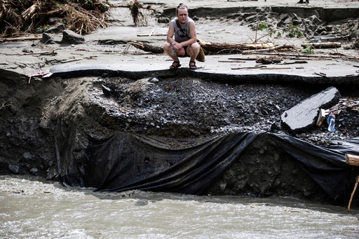
But look at Hurricane Beryl, which hit Texas this week as a “mere” Category 1 storm — far weaker in wind strength than when it swept through the Caribbean as a Cat 5 just days earlier — yet still knocked out power to 2.7 million customers. The storm has been blamed for eight deaths in the U.S.
Beryl is not the only example. By the numbers, Tropical Storm Fay in 2008 didn’t even register on the scale of dangerous storms before it made four separate landfalls in Florida. In this case, it was not Fay’s strength, but its speed — or lack thereof — that turned out to be the key. The listless storm parked itself over the state for days, dumping as much as 25 inches (64 centimeters) of rain in some places. Floods killed crops and destroyed homes. Roads were so flooded that alligators swam alongside first responders as they rescued people stranded in their homes.
What’s in a number?
An overwhelmed residents surveys the damage following flooding caused by the remnants of Hurricane Beryl, Thursday, July 11, 2024, in Plainfield, Vt. (AP Photo/Dmitry Belyakov)
Photo: ASSOCIATED PRESS/Dmitry Belyakov
The Saffir-Simpson Scale — which measures the strength of a hurricane’s winds on a scale of Category 1 to Category 5, with 5 being the strongest — was introduced to the public in 1973, the year that gas prices spiked from 39 cents to 55 cents a gallon and Tony Orlando and Dawn had the #1 hit of the year with “Tie a Yellow Ribbon Round the Ole Oak Tree.”
In other words, times have changed, and so should the way people think about how dangerous a storm is when it’s heading their way.
Or think about it in terms of your health: While it’s important to check your blood pressure, it’s only one of many measures that determine how fit you are.
When monitoring storms, “Don’t focus on the category,” advises Craig Fugate, former director of the Federal Emergency Management Agency who also was emergency management director in Florida during some of the state’s worst storms. “We really need to talk about the hurricane’s impacts, not a number” that applies only to wind strength.
Forecasters developed the Saffir-Simpson scale — and other tools such as flood maps and storm prediction cones — as a type of shorthand to easily and quickly convey a storm’s severity and reach, but they have taken on oversize roles, Fugate said.
“We’re finding that there’s a lot of things in emergency management where we didn’t really think through how we’re going to communicate, and we ended up stuck with these legacy descriptions that are hard to shake,” he said.
The circumference of a storm, how fast it’s moving and the amount of rain it delivers are all factors that matter, as is the place where it hits: its geography, its population and the quality of its infrastructure. Also, it’s important to remember that tornadoes can form regardless of a storm’s size.
It’s not just about strength
A Category 5 storm that’s compact and moving quickly could cause far less damage than a weaker, wetter storm with a huge circumference that stalls over a populated area, Fugate notes.
For example, Hurricane Charley and Hurricane Ida were both Category 4 storms. But Charley, which struck Florida’s southwest Gulf Coast in 2004, was compact and lost strength quickly as it moved inland. Ida, which came ashore in Louisiana in 2021, spawned deadly tornadoes and catastrophic flooding as far away as the northeastern United States. Sixty people were killed in New York and New Jersey alone. It also turned out to be the second-costliest storm in U.S. history, surpassed only by Hurricane Katrina.
“Charley was a Cat 4 and was very devastating where it made landfall, but Hurricane Ida was a much bigger storm and caused much more widespread devastation,” Fugate noted.
Stay local
It’s fine to follow The Weather Channel and watch updates from the National Hurricane Center when a storm forms and starts making its way toward land, but the closer it gets, the better it is to seek out local weather information, Fugate says.
“Everyone focuses on the Hurricane Center,” he said. “They’re responsible for storm intensity and track. They’re not necessarily going to have all the local impacts.”
A better place to go as a storm approaches, Fugate says, is the National Weather Service’s homepage, where you can type in a ZIP code and see what’s happening in your area.
“Your (regional) National Weather Service office is taking all that information and they’re localizing it so they can tell you what kind of wind you can expect, what kind of flooding you can expect,” Fugate says. “Are you in a storm surge area? When are the high tides?”
Don’t make assumptions
Relying on FEMA flood zone maps to determine a storm’s potential impact is as ill-advised as depending solely on the Saffir-Simpson scale, Fugate warns.
“People think, ‘Well, it’s a flood map. If I don’t live in the zone, I don’t flood.’ No! It’s an insurance rate map. Not being in that special risk area doesn’t mean you don’t flood, it just means the insurance is cheaper.”
Also, don’t be fooled by the term “100-year-flood zone.” It does not, as many assume, mean that the zone only floods every 100 years; rather that there is a 1% risk of flooding, Fugate notes.
Finally, don’t be misled by the forecast cone.
The cone — which for a reason is called the “cone of uncertainty” — shows where the center of a hurricane might go, but not how far out storm-force winds will extend.
People can be injured, killed or have heavy property losses outside the cone — a lesson that residents in the Northeast learned during Ida.
One mistake is to look at the graphic and think, “‘I’m not in the cone, I’m good,’” Fugate says. “That’s not what it means!”
Copyright 2024 The Associated Press. All rights reserved. This material may not be published, broadcast, rewritten or redistributed without permission.